MapBiomas Ecuador
  • About MapBiomas
    • The Project
    • Products
    • About us
    • Team
    • MapBiomas Initiatives
    • Premio MapBiomas Ecuador
    • Terms of use
  • Maps and data
    • Access the platform
    • Statistics
    • Downloads
    • Accuracy analysis
    • Terms of use
  • Method
    • Methodology Overview
    • ATBD - step by step
    • MapBiomas Water Method
    • Tools
    • Glossary
    • Terms of use
  • FAQ
  • Communication
    • Releases
    • MapBiomas Articles
    • Videos
    • News
    • Brand guidelines
    • Terms of use
  • Contact
User
MapBiomas

MapBiomas Articles

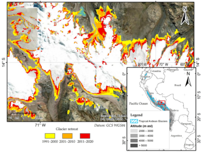
Mapping Three Decades of Changes in the Tropical Andean Glaciers Using Landsat Data Processed in the Earth Engine

Provided by Seeg

Powered by Google earth engine

© 2025 MapBiomas. All rights reserved.

Language

Development EcoStage